This page contains posts from non-current weather events. All information on this page is old, not current, and maintained for preservation of records.
2/21/2013 – 2048
The Clinton County / Cameron EOC suspended operations at 2000 hours this evening. Clinton County received snow raging from 8 to 10 inches, with light snow and freezing drizzle still falling. This will continue off and on throughout the overnight hours.
2/21/2013 – 1800
Several smaller bands of snow and sleet are being ejected by the upper level vortex centered over Eastern Kansas. These will progress through the Kansas City metro area, and Northeast through Clinton County. Some of these bands may cause locally heavy snowfall after dark. Roads remain snow covered, and impassible in rural areas.
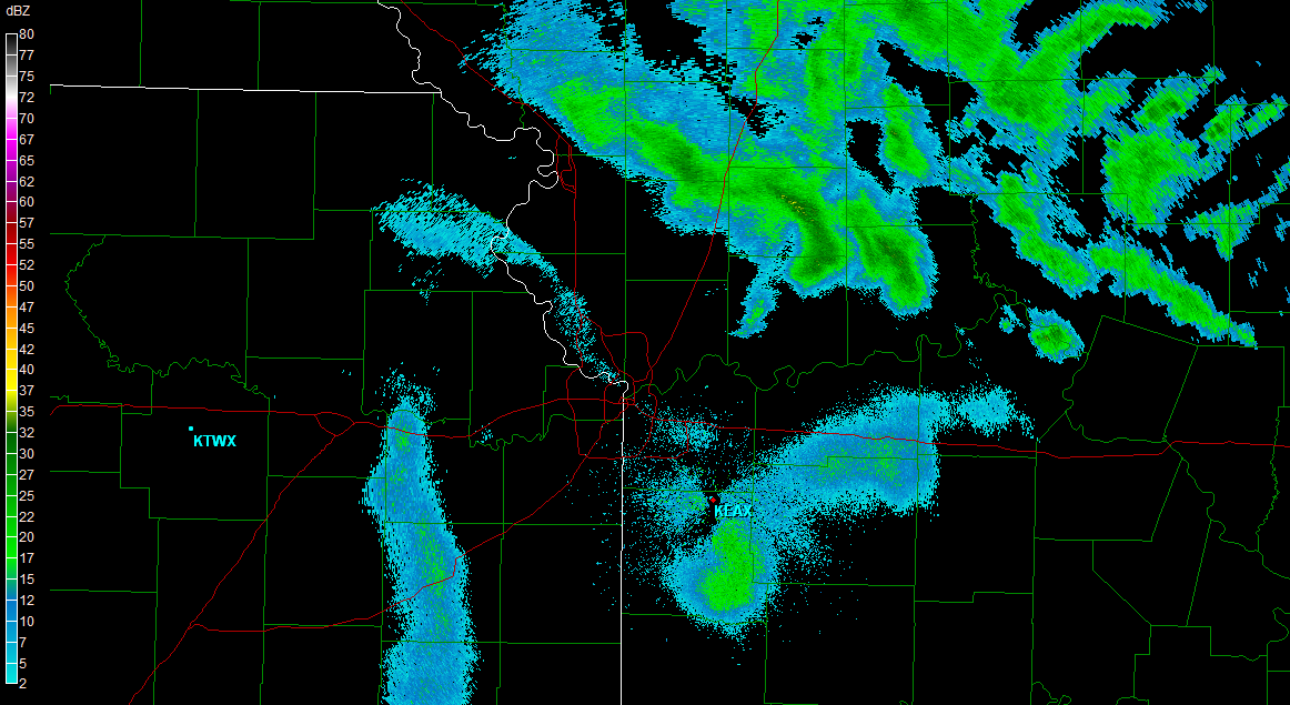
2/21/2013 – 1248
Snow is begining to taper in Clinton County for this portion of the storm. Accumulations total around 4 inches in Cameron, and 6 to 8 inches in Southern Clinton County.
Currently, a dry slot is progressing into the area, causing a pause in the snow. We expect this dry slot to fill in with moist air, causing snow to begin to overspread the area once more. This will likely bring and additional 2 to 6 inches of snow of Clinton County.
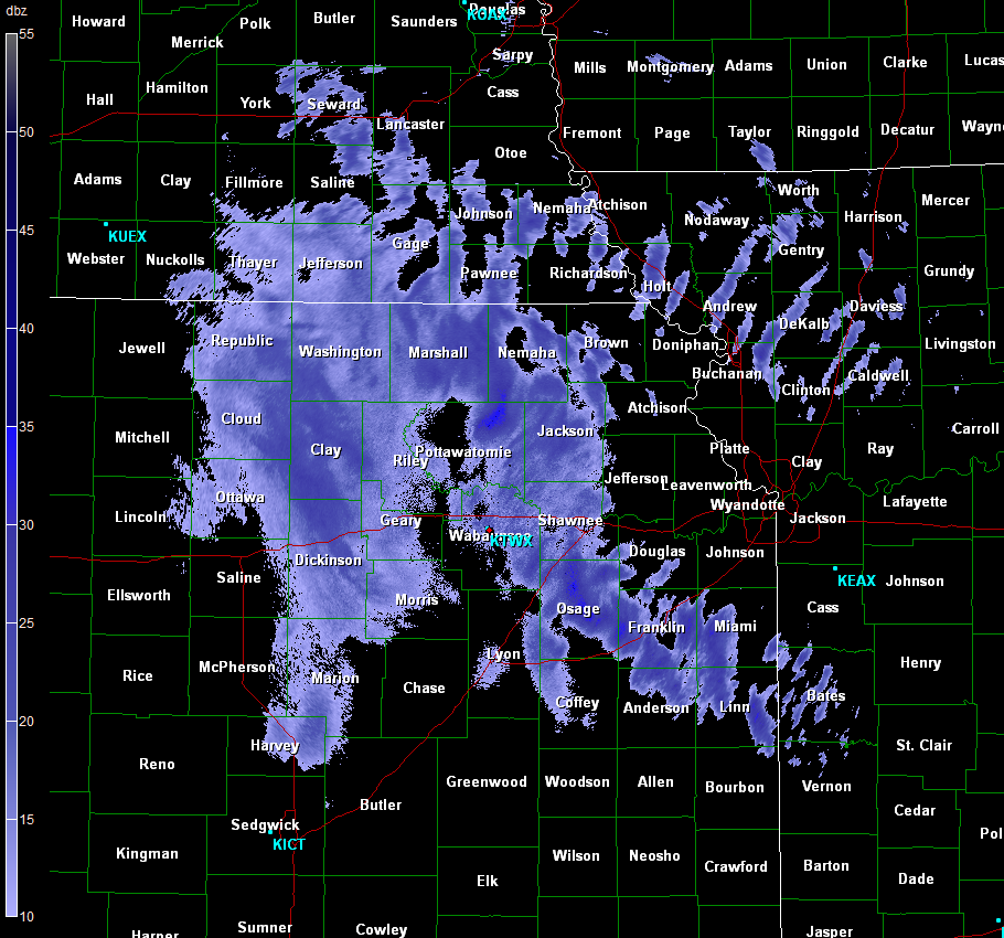
2/21/2013 – 0900
Heavy snow has overspread Clinton County. Areas in the KC metro are reporting current accumulations in excess of 5 inches, with snowfall beginning about two hours ago. This means snow is falling at a rate greater than 2 inches per hour.
2/20/2013 – 2100
ALL COUNTY OFFICES WILL BE CLOSED TOMORROW, 2/20/2013 DUE TO WINTER WEATHER. THIS INCLUDES OFFICES IN THE COURTHOUSE, AND THE HEALTH DEPARTMENT.
Updated forecast graphic below. No major changes to the storm forecast.
2/20/2013 – 0743
The National Weather Service has issued a WINTER STORM WARNING for Clinton County effective Midnight tonight through 6AM Friday.
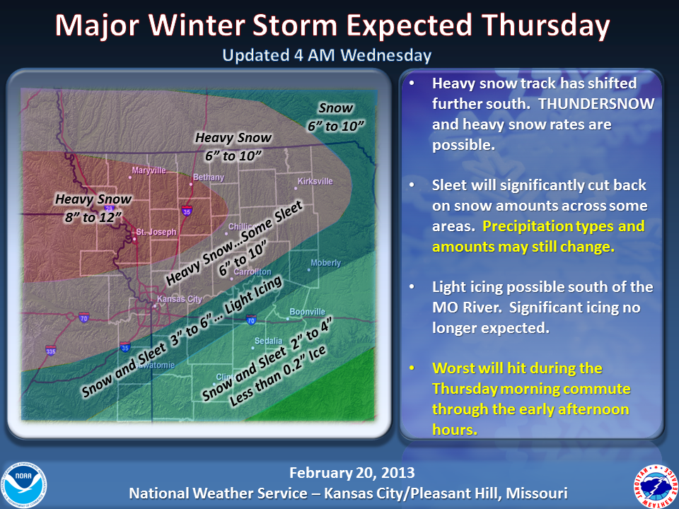
This morning’s forecast places Northern Clinton County withing the 8-12 inch snowfall range, with Southern portions of the County in the 6-10 inch range. Further adjustments of these predictions will be made as the storm nears, and it’s exact path and speed become more clear.
Text of the winter Storm Warning follows:
URGENT - WINTER WEATHER MESSAGE
NATIONAL WEATHER SERVICE KANSAS CITY/PLEASANT HILL MO
333 AM CST WED FEB 20 2013

...WINTER STORM WEDNESDAY NIGHT AND THURSDAY...

.A STRONG WINTER STORM WILL AFFECT MUCH OF THE REGION LATE
WEDNESDAY NIGHT AND THURSDAY...BRINGING A WIDE MIXTURE OF WINTRY
PRECIPITATION. THE HEAVIEST SNOW IS GENERALLY EXPECTED NORTH OF
AN ATCHISON KANSAS TO KIRKSVILLE MISSOURI LINE...WITH THE HIGHEST
ICE ACCUMULATIONS SOUTH OF MOUND CITY KANSAS TO CLINTON...SEDALIA...
BOONVILLE MISSOURI LINE. A MIXTURE OF HEAVY SNOW AND SLEET WILL
OCCUR IN BETWEEN THESE AREAS.

...WINTER STORM WARNING IN EFFECT FROM MIDNIGHT TONIGHT TO 6 AM
CST FRIDAY...

THE NATIONAL WEATHER SERVICE IN KANSAS CITY/PLEASANT HILL HAS
ISSUED A WINTER STORM WARNING FOR HEAVY SNOW...WHICH IS IN EFFECT
FROM MIDNIGHT TONIGHT TO 6 AM CST FRIDAY. THE WINTER STORM WATCH IS
NO LONGER IN EFFECT.

* TIMING...LATE WEDNESDAY NIGHT THROUGH EARLY FRIDAY MORNING. THE
  HEAVIEST PRECIPITATION WILL OCCUR THURSDAY MORNING INTO EARLY
  AFTERNOON AND MAY HAVE SIGNIFICANT IMPACTS ON THE MORNING COMMUTE.

* SNOW ACCUMULATIONS...8 TO 12 INCHES.

* IMPACTS...HEAVY SNOW WILL HAVE SIGNIFICANT IMPACTS ON TRAVEL. SNOW
  ACCUMULATIONS MAY EXCEED AN INCH PER HOUR AT TIMES.

* OTHER IMPACTS...FREEZING DRIZZLE MAY MIX IN AT TIMES... ESPECIALLY
  THURSDAY AFTERNOON AND EVENING.

PRECAUTIONARY/PREPAREDNESS ACTIONS...

A WINTER STORM WARNING FOR HEAVY SNOW MEANS SEVERE WINTER WEATHER
CONDITIONS ARE EXPECTED OR OCCURRING.  SIGNIFICANT AMOUNTS OF SNOW
ARE FORECAST THAT WILL MAKE TRAVEL DANGEROUS. ONLY TRAVEL IN AN
EMERGENCY. IF YOU MUST TRAVEL...KEEP AN EXTRA FLASHLIGHT...FOOD...AND
WATER IN YOUR VEHICLE IN CASE OF AN EMERGENCY.
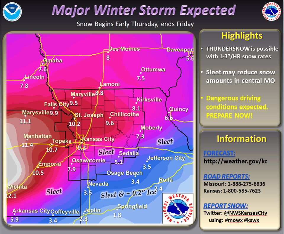
2/19/2013 – 2224
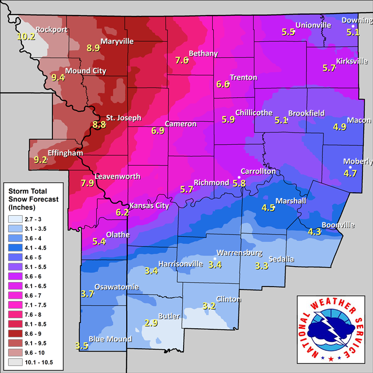
Expected snowfall totals from 1600 2/19/2013. We expect further revisions of this estimate as the storm system draws nearer.
2/19/2013 – 1337
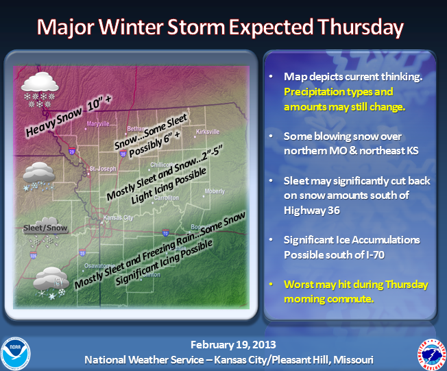
Updated forecast graphic from late this morning. This system is begining to look more like a large snowfall event vs wintry mix event. There will likely still be some sleet and or small amount of freezing rain, but the largest factor involved will be the snowfall. Wind will also cause drifting, as gusts up to 35mph are forecast.
2/19/2013 – 0829
Winter Storm Watch Issued
…WINTER STORM LIKELY WEDNESDAY NIGHT AND THURSDAY…
.A STRONG WINTER STORM WILL AFFECT MUCH OF THE REGION LATE WEDNESDAY
NIGHT AND THURSDAY…BRINGING A WIDE MIXTURE OF WINTRY
PRECIPITATION. THE POTENTIAL EXISTS FOR SIGNIFICANT SNOW AND ICE
ACCUMULATIONS. THE HEAVIEST SNOW IS GENERALLY EXPECTED NORTH OF
HIGHWAY 36…WITH THE HIGHEST ICE ACCUMULATIONS SOUTH OF HIGHWAY 50.
A MIXTURE OF SNOW…SLEET AND FREEZING RAIN WILL OCCUR IN BETWEEN
THESE AREAS.
…WINTER STORM WATCH IN EFFECT FROM WEDNESDAY EVENING THROUGH
THURSDAY AFTERNOON…
THE NATIONAL WEATHER SERVICE IN KANSAS CITY/PLEASANT HILL HAS
ISSUED A WINTER STORM WATCH…WHICH IS IN EFFECT FROM WEDNESDAY
EVENING THROUGH THURSDAY AFTERNOON.
* TIMING…LATE WEDNESDAY NIGHT THROUGH THURSDAY AFTERNOON. THE
HEAVIEST PRECIPITATION WILL OCCUR THURSDAY MORNING AND MAY HAVE
SIGNIFICANT IMPACTS ON THE MORNING COMMUTE.
* SNOW/ICE ACCUMULATIONS…THE POTENTIAL EXISTS FOR SIGNIFICANT
SNOW…SLEET AND ICE ACCUMULATIONS. THE HEAVIEST SNOW WILL
GENERALLY FALL NORTH OF A LEAVENWORTH TO RICHMOND LINE…WHILE THE
GREATEST THREAT FOR ICE ACCUMULATIONS WILL BE ALONG AND SOUTH OF A
PAOLA TO WARRENSBURG LINE. A MIX OF SNOW…SLEET AND FREEZING RAIN
WILL OCCUR IN BETWEEN THESE AREAS.
* IMPACTS…HEAVY SNOW…SLEET AND ICE ACCUMULATIONS WILL HAVE
SIGNIFICANT IMPACTS ON TRAVEL. ICE MAY CAUSE DAMAGE TO TREES AND
POWER LINES.
PRECAUTIONARY/PREPAREDNESS ACTIONS…
A WINTER STORM WATCH MEANS THERE IS A POTENTIAL FOR SIGNIFICANT
SNOW…SLEET…OR ICE ACCUMULATIONS THAT MAY IMPACT TRAVEL.
CONTINUE TO MONITOR THE LATEST FORECASTS.
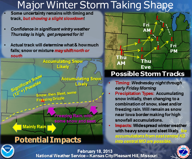
2/18/2013 – 2013
The weather service has issued an updated graphic. Current models suggest a slight move South for the surface low connected with this storm. This will move the freezing line South. This means less risk of freezing rain for Clinton County, but an increased chance for more snowfall. Amounts remain undetermined, and there is still plenty of potential for a change in track.
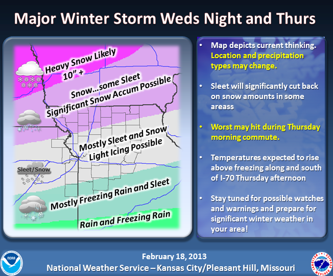
2/18/2013 – 0845
The weather service has issued updated guidance on precipitation amounts and types. The graphic below explains the current forecast. Be aware that this forecast will continue to change and evolve as the storm system draws nearer.
2/17/2013
Currently following the development of a potentially major winter storm which is currently tracking along the Canadian West Coast. It is expected to impact our region beginning Wednesday night through early Friday. More information will be provided as it develops.